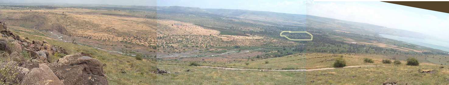
View along Jordan River Valley from near Karkom - April 2005 -- SCROLL RIGHT --------------------------------------------------------------------------------------------------------->>>>>>>>>>>>>
ISRAEL PHOTOS III -- A COLLECTION OF PHOTOS FROM ISRAELWITH DESCRIPTIONS OF SCENES AND SITES PERTINENT TO THE STUDY OF CHRISTIANITY |
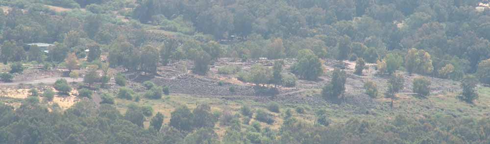
A view of the ruins from near Karkom - April 2005
According to John 1:44, the disciples Philip, Andrew, and Peter were from Bethsaida.
The first century historian Josephus wrote about Bethsaida also: "When Philip also had built Paneas, a city at the fountains of Jordan, he named it Caesarea. He also advanced the village Bethsaida, situate at the lake of Gennesareth, unto the dignity of a city, both by the number of inhabitants it contained, and its other grandeur, and called it by the name of Julias, the same name with Caesar's daughter." Antiquities of the Jews, by Flavius Josephus, Book 18, Chapter 1
The ancient ruins of Bethsaida are circled in yellow in the upper photo - to the right. This ruin seems to be the ruins of Bethsaida-Julia, after numerous researchers described this location as probable. A spring flowing into a tributary of the river Jordan flowed out of the side of the hill.
More likely than Bethsaida being only the town on the mound, it was a region around the town as far as the region of the next large town. There was probably a fish market in Bethsaida and fishermen living there might have carried their catch back to the city. As the case with Gadara, the harbor of Bethsaida may have been some distance from the city walls. I inserted this text on 8/7/17 after the publication of the discovery of a Roman bath house at El Araj. El Araj is along the shore of the lake near the mouth of the Jordan River. It has been recently identified as a probable location for Bethsaida after recent excavations revealed a Roman era bath house and artifacts dating from the first to third centuries. In 1998 Mendel Nun (amateur archaeologist/school teacher at Kibbutz En Gev) reported finding a Herodian era lamp at El Araj. This region has a history of severe earthquakes that may have changed the lake level over two thousand years. In 1837 an earthquake destroyed much of Tiberias and Safed killing thousands and leveling many houses. In 1927 an earthquake killed hundreds in this area. Capernaum, Bethsaida and Chorazin have been leveled
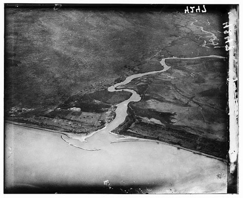
Jordan River delta - aerial photo (LOC collection listed as 1910-1946, probably 1930's series)
JULY 2006 BETHSAIDA PANORAMA PHOTO
BETHSAIDA A CITY BY THE NORTH SHORE OF THE SEA OF GALILEE Volume One edited by Rami Arav and Richard A. Freund, copyright 1995
Parable of the Mustard Seed
A Mustard Field Along Highway 87-North Shore of Galilee
Mustard Seeds in the Palm of a Hand
Mustard Flowers
Giant Mustard
Upper Most Seats of the Synagogue
The Fig Tree
Mt of Olives Fig Tree, April 12-13, 2005
Fig and Pomegranite Trees Below Siloam in Jerusalem
Sycomore Fig Tree
The Good Shepherd
The Parable of the Sheep and the Goats
Goat Herder
Camels
Ritual Cleansing
Shechem
The Olive Harvest of Samaria
Mt. Ebal
Olive Tree
Pearl of Great Price
A First Century Synagogue at Gamala
Overview of Gamala
Modern Galilee Fishing Boats
Kursi
Caves and/or Tombs
Steep Slope Near Kursi
Hippos
Feeding the 5,000
On the Mountain
Walking on Water
Ramot-Tzelon area
Mt. Hermon
The Pools of Bethesda in Jerusalem
Healing Pools
Crusader Chapel and St. Ann Church
Pool of Siloam in Jerusalem
Hezekiah's Tunnel
Overlook to Siloam
Tower of Siloam
A Watch Tower in a Vineyard/Olive Grove
Grape Vines at Beth Horan
Towers
Mt. Precipice
South Face
Summit
Over the edge
Measuring Line
View of Nazareth from near Megiddo
Nazareth
The Basilica of the Annunciation
Capernaum
Healing a Paralytic in Capernaum
Bethsaida
Waterskins and Wineskins
The Fish and the Coin
Barbel
A Denarius
Casting Out a Demon
The Road to Jericho
Old Roman Road
Wilderness Above Jericho
Old Jericho
Western Wall
Gethsemane and the Cave of Gethsemane
Church of the Holy Sepulcher
Rolling Stone Tombs - Jerusalem
Other Rolling Stone Tombs
Tiberias
Solar Power in Israel
Salt of the earth
Chorazin
OTHER WEB SITES BY DAVID HALL:
Israel Photos VI
Israel Photos V -- Spring 2011
Israel Photos IV -- Pilgrimage
DQHALL.COM