ISRAEL PHOTOS IV -- Pilgrimage |
The Precipice Southwest of Nazareth
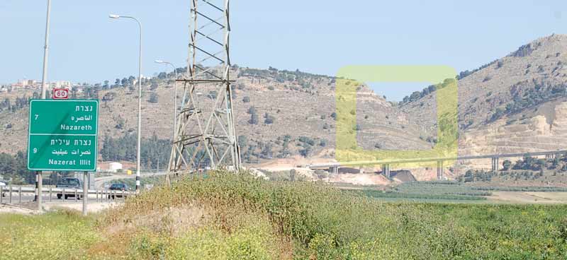
The view from seven kilometers outside of Nazareth by road (4/2008). The area in the yellow block was a platform and niche built to commemorate the base of the cliff where the town's people conspired to hurl Jesus downward. Jesus was able to escape. The worship site was in use perhaps as early as the Byzantine period. There are also high cliffs on the mountain to the right and lesser precipices in town that might have been the location of the event described in the Gospel According to Luke. The higher peak to the right is Jebel el Qafseh. The hill to the left is by the Latin tradition "the Fright." There was a different Greek traditional observance of the fright. There were two different annunciation theories. Many of the churches marking Holy Sites in Israel may have been guesses. There are two churches marking the birth site of St. Anne, one in Jerusalem, another in Sephoris more than two days walking distance from Jerusalem.
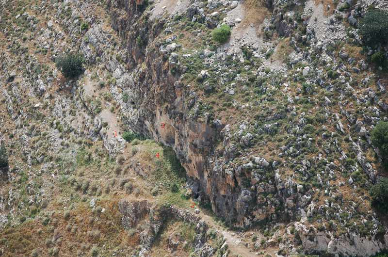
1. A cistern with the fig growing out of it to the right of numeral, partially filled in, seven feet deep.
2. A bell cistern with narrow dark opening, twenty-three feet deep.
3. Manmade niche in the limestone wall used for worship purposes.
4. Platform with stone retaining walls below and steps to the right used by worshipers who approached the site.
The cliff is probably more than forty feet high.
This location (same as shown above) was reported since Medieval times. It is the precipice near a notch between the two mountains southwest of town as one goes up towards Nazareth. Its distance from Nazareth has been described as between one and two miles from town. Franciscan archaeologist Bagatti reported Byzantine shards mixed in the fill used to build the platform. Use of this site to commemorate Luke's account may date back to the Byzantine era. There are records of an old Nubian Christian monastery below the cliff. The recent construction project for a highway tunnel under Jebel el Qafseh into Nazareth has destroyed much of the level land below the precipice. Some objected to the fact that this precipice seemed far from town. One might remember that John the Baptist was imprisoned in one of Herod's fortresses. Paul was transported by horse to Caesarea then to Rome to stand trial. Josephus indicated rebels who were captured when the Jewish resistance failed (70 A.D. War of the Jews) were transported as far away as Corinth to serve as slaves digging a canal. People arrested or seized were sometimes transported greater distances than this cliff is to the center of Nazareth. A cliff this close to Nazareth cannot be ruled out, nor should one ignore the cliffs near the well spring at the town center as context for the Gospels.
Early Travels in Palestine, Thomas Wright, London, 1848
From the writings of Henry Maundrell (A.D. 1697):
"...After dinner we made another small excursion, in order to see that which they call the Mountain of the Precipitation; that is, the brow of the hill from which the Nazarites would have thrown down our blessed Saviour, being incensed at his sermon preached to them. This precipice is at least half a league (1.5 miles) distant from Nazareth southward. In going to it, you cross first over the valley in which Nazareth stands, and then, going down two or three furlongs in a narrow cleft between the rocks, you there clamber up a short but difficult way on the right hand, at the top of which you find a great stone standing on the brink of the precipice, which is said to be the very place where our Lord was destined to be thrown down by his enraged neighbors, had he not made a miraculous escape out of their hands. There are in the stone several little holes, resembling the prints of fingers thrust into it. These, if the friars say truth, are the impresses of Christ’s fingers, made in the hard stone, while he resisted the violence that was offered to him. At this place are seen two or three cisterns for saving water, and a few ruins, which are all that now remains of a religious building..."
From: Popular Description Of Palestine Or The Holy Land, Josiah Conder, London, 1831:
"The road to the "mountain of the precipitation" lies over a tolerably level space for about a mile, winding in a southern direction; it then becomes necessary to dismount, on account of the ruggedness of the road, which descends into a deep ravine between two hills. After scrambling up the southern point for about a quarter of an hour, you arrive at an altar in a recess hewn out of rock, and some remains of a mosaic pavement. Near it are two large circular cisterns, well stuccoed inside, and several portions of buildings, said to be the remains of an establishment founded by St Helena. The monks come here sometimes, to celebrate mass. Immediately over this spot, about forty feet higher, two large flat stones are set up edgeways, like a parapet wall, close to the edge of the precipice (described in the Gospel)."
Nazareth Synagogue
Churches of the Annunciation
Latin Tradition -- Mount of Precipitation
Nazareth Aerial View
Museum of the Basilica
Hot Springs at Tiberias
Stone Water Jars at Capernaum
Capernaum
Tabgha
Bethsaida
A 1909 Galilee Fishing Description
The Giant Mustard Plant
Kursi and the Gadarene Demoniac
Jar of Ointment
Cana
Wheat and Tares