ISRAEL PHOTOS IV -- Pilgrimage |
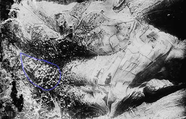
NAZARETH AERIAL VIEW
This is an aerial photo of Nazareth c. 1920. The low hill highlighted in blue is the area of the first century village of Nazareth. At the right end of the hill is Mary's Well; the only year round spring in Nazareth. There is a shallow well of about six feet down to the spring of water. The spring supported the village through the dry season when there was no rain for months at a time. Franciscan archaeologists found first century pottery during church renovations and other building projects in Nazareth. The mountain on the photo above the blue zone contained first century tombs and pottery from the time of Jesus. Since first century Jews only built tombs where they outside of their town, the village was confined to this hollow in the mountain. The was cultivated with fig, almond, and pomegranate trees. Before Nazareth became a city, there were reports of grain, vegetables, and other field crops being grown on the plateau to the left of the blue zone. There were numerous cisterns and grain silos found in the limestone bedrock Nazareth was founded on. Nazareth was above the environs of the Esdraelon Plain about halfway between the Mediterranean Sea and Lake Tiberias (Sea of Galilee).
Eusebius, c. 325 A.D., described Nazareth as being 15 mile stones from Legio/Lejjun. Archaeologists have confirmed a large Roman Legion camp in the rolling terrain behind Megiddo. This camp has been described as Legio. In the late fourth century Jerome described Nazareth as Nazara 15 mile markers across the Esdraelon Plain from Leggio near Tabor. In the 19th century pilgrims reported the village of Nazareth was named Ain Nasara (Nasara Spring). The name Nazareth may have been derived from the Semitic netzer - meaning branch.
Nazareth Synagogue
Churches of the Annunciation
Latin Tradition -- Mount of Precipitation
Nazareth Aerial View
Museum of the Basilica
Hot Springs at Tiberias
Stone Water Jars at Capernaum
Capernaum
Tabgha
Bethsaida
A 1909 Galilee Fishing Description
The Giant Mustard Plant
Kursi and the Gadarene Demoniac
Jar of Ointment
Cana
Wheat and Tares